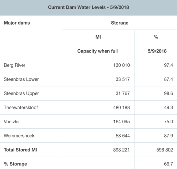
The bountiful downpour over the past two days has already had positive effects on the dam levels as they continue to rise, reaching 66.7% as of today.
Two more days of rain are still on the cards for Cape Town, and locals are keeping fingers crossed that the rainfall will usher water storage into 70% capacity, a level not reached from nearly two years now.

The next two days are also expected to be chilly ones while a cold front moves over the continent, windy conditions are also in the forecast till Friday evening.
The cold front is expected to make landfall this afternoon bringing showers and rain in the western parts of the country, otherwise over the interior dry and windy conditions. Fog and low level cloud observed over KZN going into eSwatini. Enjoy your day. @ReenvalSA pic.twitter.com/sEj0KBxRPX
— SA Weather Service (@SAWeatherServic) September 4, 2018
After Friday the weather will clear up and offer perfect weekend conditions for being active and going out. Rain is only expected to return to the Cape again from next week Wednesday.

Time-lapse captures the stunning winter Theewaterskloof dam just had
In just five months, Theewaterskloof dam went from half-dead to half-full This time-lapse video will leave you speechless? @planetlabs https://t.co/DJak5cAiEL … #PlanetStories pic.twitter.com/ZuxZr8IOEV
— ReenvalSA (@ReenvalSA) September 4, 2018
#Theewaterskloof dam opvangs gebied. Ontelbare seëninge van bo vandag ? : Andre Rassie Erasmus @SAWeatherServic @cptweather @capetowndrought @venter_annette @debeer_anika @AgriWesKaap pic.twitter.com/soksKQ4yAy
— ReenvalSA (@ReenvalSA) September 5, 2018
#DWARSKERSBOS
31 Aug 19mm
1 Sept 5mm
5 Sept 18mm
?: Naomi Janetta Pienaar Coetzee @SAWeatherServic @JoelGuy_ @AfricaWeather_ @venter_annette @ewnupdates @debeer_anika @AgriWesKaap pic.twitter.com/4U5tDWpsDs— ReenvalSA (@ReenvalSA) September 5, 2018
Picture: Twitter

