The Western Cape is in for more icy cold weather and forecasters have even predicted snowfall, as a cold front makes its way to the province.
Storm Report SA’s weather models suggests a strong cold front will make landfall in the Western Cape by Wednesday, June 10.
Widespread snowfall along high-lying areas is expected from the Western Cape to the Eastern Cape, Northern Cape, Free State and Lesotho.
The chilly weather will be accompanied by heavy rainfall starting from June 10, extending through to the rest of the week.
High-lying areas will experience the most snow, with areas like Sutherland, Matroosberg and Swartberg Pass in for some heavy snowfall.

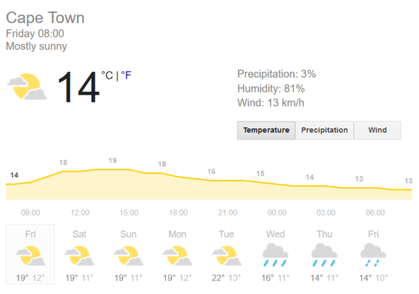
Temperatures for the rest of this week and the beginning of next week are expected to be mild, ranging between highs of 19°C and lows of 11°C , with mostly sunny conditions. On Tuesday, June 9 the clouds roll in and warmer temperatures of up to 22°C are predicted by Weather.com.
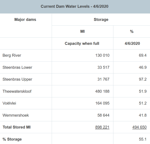
Dam levels are inching closer to the 60% mark again, currently at 55.1% as of June 4.
Hopefully the bountiful rains next week will bolster the overall storage levels. The fullest dams are Steenbras Upper at 97.2% and Berg River at 69.4%.

Forecasters say the weather could change at the last minute but it looks like the Western Cape is in for snow.
Picture: Pixabay

