Locals can look forward to bountiful rains in Cape Town tonight.
The heavy downpours forecast for late on Sunday night will be the Cape’s first big rains for the wet winter season.
Although rain is always welcome in the Mother City there are concerns that they may cause flooding and subsequent damage in some areas.
Rain is expected to fall in areas throughout the province, including the Breede Valley, Cederberg, Paarl, Stellenbosch, and Theewaterskloof.
The rest of Sunday will be partly cloudy with highs of 17°C and lows of 13°C before the showers start in the late hours of the evening.

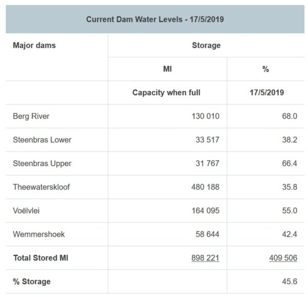
The rains are expected to help Cape Town’s dam levels as well. Currently, overall storage is at 45.6% with the lowest dams such as Theewaterskloof at 35.8% and Steenbras Lower at 38.2%.
A #coldfront will be moving in over the #WesternCape on Sunday night into Monday morning bringing much needed #rain for #CapeTown and surrounding mountain catchment regions. A heavy rainfall/localized flooding WATCH has been issued for some areas. Updates to follow. pic.twitter.com/AHPbBzJD8g
— SA Weather Service (@SAWeatherServic) May 18, 2019
A heavy rainfall and localized flooding watch has been issued for some areas around the Cape.
The City of Cape’s Disaster Risk Management Centre has teams on standby in the event of any problems arising and locals are encouraged to contact them should they experience or witness any issues.
Telephone: 080 911 4357
Email: [email protected]
Also read: Dam levels to carry Cape through the winter.
Picture: Pexels

