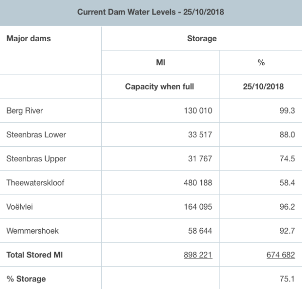
The heat coupled with an increase in water consumption has continued to put strain on the storage level of Cape Town’s five major dams – overall levels are at 75.1% as of today.
Theewaterskloof is at just over 58% storage capacity, Steenbras Upper has slipped to 74.5% and Steenbras Lower is at 88% with other dams dipping slightly but staying above 90%.

The hot weather is expected to continue in Cape Town till next week Monday, with possible rain coming in on Tuesday.
Sunday will, however, usher in some of the highest temperatures Cape Town has seen yet, before locals are given a breather.
#Hartenbos skroei vandag…! Termometer wys 40grade ?: Jan En Marina Sauer @cptweather @CityofCT @eNCAWeather @SAWeatherServic @dieCourant @Die_Burger @venter_annette @debeer_anika @maroelamedia @JoelGuy_ @Netwerk24 @huisgenoot @Dispatch_DD pic.twitter.com/P6BV0fNgAw
— ReenvalSA (@ReenvalSA) October 23, 2018
In Despatch ?: Veronica F Boucher @Dispatch_DD @eNCAWeather @SAWeatherServic @JoelGuy_ @huisgenoot @kobusbotha @weathertodaysa @cptweather @AfricaWeather_ pic.twitter.com/CWhfTmFH02
— ReenvalSA (@ReenvalSA) October 23, 2018
#Langebaan kook vandag ?: Izell Gouws @eNCAWeather @SAWeatherServic @maroelamedia @AfricaWeather_ @JoelGuy_ @venter_annette @debeer_anika @_ArriveAlive @ewnupdates @dieCourant @Die_Burger pic.twitter.com/4AcoMPy6vs
— ReenvalSA (@ReenvalSA) October 23, 2018
Dit gaan warm wees. https://t.co/lappfUvHXU
— ReenvalSA (@ReenvalSA) October 23, 2018
?OCTOBER RECORDS IN THE 24HRS TO 8AM TODAY?
RECORD MIN:
– Cape Town CBD 23.9ºC, previous high MIN 21.8ºC
RECORD MAX:
– Strand 36.7ºC, previous high 34.9ºC
– Mossel Bay 39.0ºC, previous high 36.7ºC
– Knysna 39.5ºC, previous high 38.5ºC
Source – SAWS@landbou @ReenvalSA @CapeTalk pic.twitter.com/6ZBpiX4CE1— AfricaWeather (@AfricaWeather_) October 24, 2018
Picture: The City Of Cape Town

